
Page 43 - 香港房屋委员会年报 Hong Kong Housing Authority Annual Report
P. 43
主要工作
Key Achievements 41
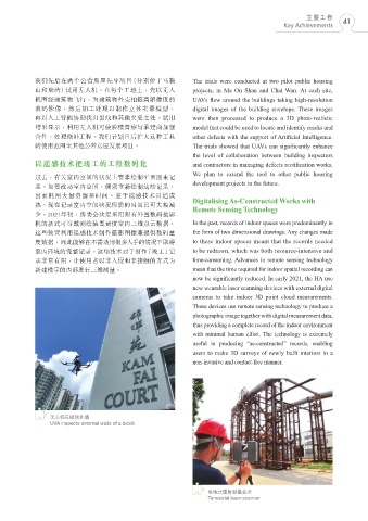
我們先後在兩個公營房屋先導項目(分別位於馬鞍 The trials were conducted at two pilot public housing
山和柴灣)試用無人機。在每個工地上,先以無人 projects, in Ma On Shan and Chai Wan. At each site,
機圍繞建築物飛行,為建築物外殼拍攝高解像度的 UAVs flew around the buildings taking high-resolution
數碼影像,然後加工處理以製作立體實景模型, digital images of the building envelope. These images
再以人工智能協助找出裂紋和其他欠妥之處。試用 were then processed to produce a 3D photo-realistic
結果顯示,利用無人機可使驗樓督察與承建商加強 model that could be used to locate and identify cracks and
合作,處理修補工程。我們計劃日後擴大這種工具 other defects with the support of Artificial Intelligence.
的使用範圍至其他公營房屋發展項目。 The trials showed that UAVs can significantly enhance
the level of collaboration between building inspectors
以遙感技術把竣工的工程數碼化 and contractors in managing defects rectification works.
過去,有關室內空間的狀況主要靠繪製平面圖來記 We plan to extend the tool to other public housing
錄。如要改動室內空間,便須重新繪製這些記錄, development projects in the future.
因而耗用大量資源和時間。鑑於遙感技術日趨成 Digitalising As-Constructed Works with
熟,現在記錄室內空間狀況所需的時間已可大幅減 Remote Sensing Technology
少。2021年初,房委會決定採用附有外置數碼攝影
機的新式可穿戴測繪裝置量度室內三維點雲數據。 In the past, records of indoor spaces were predominantly in
這些裝置利用遙感技術製作攝影圖像兼提供數碼量 the form of two dimensional drawings. Any changes made
度數據,因此能夠在不需動用很多人手的情況下取得 to these indoor spaces meant that the records needed
室內環境的完整記錄。這項技術對於製作「竣工」記 to be redrawn, which was both resource-intensive and
錄非常有用,讓使用者以非入侵和非接觸的方式為 time-consuming. Advances in remote sensing technology
新建樓宇的內部進行三維測量。 mean that the time required for indoor spatial recording can
now be significantly reduced. In early 2021, the HA use
new wearable laser scanning devices with external digital
cameras to take indoor 3D point cloud measurements.
These devices use remote sensing technology to produce a
photographic image together with digital measurement data,
thus providing a complete record of the indoor environment
with minimal human effort. The technology is extremely
useful in producing “as-constructed” records, enabling
users to make 3D surveys of newly built interiors in a
non-invasive and contact-free manner.
無人機在檢測外牆
UVA inspects external walls of a block
坐地式雷射測量技術
Terrestrial laser scanner